Pakistan is one of the most dramatically beautiful countries on earth. It is home to five of the world’s seventeen peaks above 8,000 metres, more ancient civilisations than almost anywhere else in Asia, and a coastline that stretches 1,046 kilometres along the Arabian Sea. Yet international tourism remains low, which means that for those willing to travel here, the rewards are extraordinary — uncrowded landscapes, genuine hospitality, and places that feel genuinely undiscovered.
Most visitors to Pakistan know Hunza, Murree, or the Karakoram Highway. This guide goes beyond those well-worn routes to cover ten destinations that even many Pakistanis have not yet visited — places of remarkable beauty, cultural depth, and natural power that deserve far more attention than they currently receive.
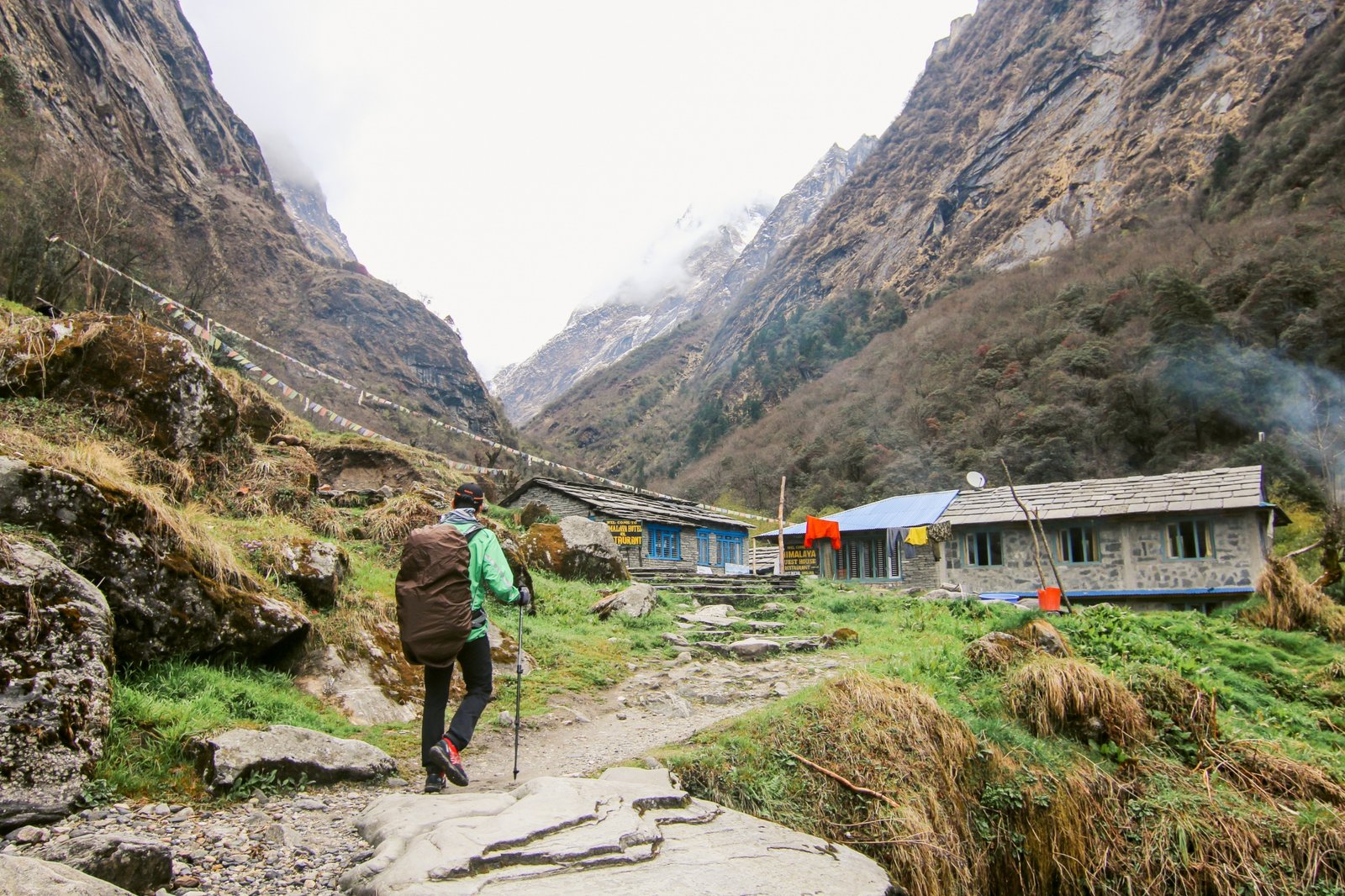
1. Ratti Gali Lake — Neelum Valley, Azad Kashmir
Elevation: 3,700 metres | Best time to visit: June to September
Ratti Gali is a glacial lake tucked into the high alpine meadows of Neelum Valley, and it is one of the most visually stunning places in Pakistan. The lake’s water is a deep, shifting turquoise that changes colour through the day as the light moves across the surrounding snow-capped peaks. In July and August, the meadows around the lake are carpeted in wildflowers — purple irises, yellow buttercups, and white alpine blooms that stretch in every direction.
Getting there requires effort, which is precisely why it remains uncrowded. From Sharda or Kel, a jeep track climbs to a base camp at around 3,000 metres, from where a two to three hour trek through increasingly dramatic mountain scenery leads to the lake. Local shepherds bring their flocks to these highlands in summer, and it is common to share the trail with goats and horses carrying supplies.
Accommodation near Ratti Gali is limited to basic campsites and a handful of guesthouses in the valley below. Bring warm clothing — temperatures drop sharply at night even in July — and be prepared for afternoon thunderstorms, which are common in August.
Practical tip: The road from Muzaffarabad to Neelum Valley follows the Line of Control and requires a permit for some sections. Check current requirements before travelling.
2. Kund Malir Beach — Makran Coast, Balochistan
Distance from Karachi: Approximately 190 km | Best time to visit: October to March
The Makran Coastal Highway is one of Pakistan’s great road trips, and Kund Malir is its most rewarding stop. The beach stretches for kilometres without a single structure in sight — no hotels, no stalls, no crowds. The sand is pale gold, the water a clear blue-green, and behind the beach rise the extraordinary geological formations of Hingol National Park: towering cliffs of compressed sandstone carved by millennia of wind into shapes that look almost architectural.
Hingol National Park — Pakistan’s largest national park at 6,100 square kilometres — surrounds Kund Malir and contains some of the country’s most surreal landscapes. The Princess of Hope rock formation, so named because of its human-like silhouette, stands near the highway. The mud volcanoes of Chandragup, active geological features that bubble with cool grey mud, are a short drive away. The park also contains the Hinglaj Mata Temple, one of the most important Hindu pilgrimage sites in Pakistan, which draws hundreds of thousands of visitors during the annual Hinglaj Yatra festival in April.
Camping on the beach is the only overnight option directly at Kund Malir. The nearest proper accommodation is in Ormara, about 60 km further along the highway. Come with a tent, plenty of water, and enough food for your stay — there are no shops at the beach itself.
Practical tip: The Makran Coastal Highway passes through areas with intermittent mobile coverage. Download offline maps before travelling. A four-wheel drive vehicle is not required for the highway itself but is strongly recommended for exploring Hingol National Park’s interior tracks.
3. Arang Kel — Neelum Valley, Azad Kashmir
Elevation: Approximately 2,400 metres | Best time to visit: April to October
Arang Kel is a small village perched on a ridge above the Neelum River, reachable only by chairlift from Kel — a short but thrilling aerial crossing above the rushing river far below. The village itself consists of traditional wooden houses, stone pathways, and meadows so green they seem almost unreal against the backdrop of pine forests and snow-capped ridges.
The appeal of Arang Kel is its complete separation from ordinary life. There are no vehicles, limited mobile connectivity, and no commercial noise. Visitors walk between homestays and guesthouses, eat simple home-cooked food — dal, roti, and whatever is seasonal — and spend their time looking at views that have changed very little in centuries. Children play in the meadows, women work in kitchen gardens, and the only sounds are wind, water, and birdsong.
Several short treks are possible from Arang Kel, including a ridge walk that offers panoramic views across the Neelum Valley into Indian-administered Kashmir. The contrast between the peacefulness of the village and the political complexity of the surrounding region is one of the quietly remarkable aspects of being here.
Practical tip: The chairlift from Kel operates during daylight hours and can have waiting times in peak season. Book accommodation in Arang Kel in advance during July and August, as guesthouses fill quickly.
4. Gorakh Hill Station — Kirthar Range, Sindh
Elevation: 1,734 metres (5,689 feet) | Best time to visit: November to February
Gorakh Hill is Sindh’s only hill station — a mountain plateau in the Kirthar Range that offers something almost no one expects from the flattest of Pakistan’s provinces: cold weather, cloud cover, and occasional snowfall in winter. The drive from Karachi takes approximately five hours through increasingly dramatic desert and mountain terrain, with the final approach winding up switchback roads above Khuzdar.
At the top, the landscape is open and windswept — grasslands and rocky outcrops stretching to the horizon, with views on clear days that seem to extend to the edge of the world. The night skies here are among the darkest in the entire country, and on clear winter nights the Milky Way is visible with exceptional clarity. Gorakh has become quietly popular among amateur astronomers and astrophotographers for precisely this reason.
Accommodation at Gorakh is basic — government rest houses and a small number of private guesthouses. The Sindh Tourism Development Corporation manages facilities at the hill station, which have improved in recent years. Bring warm clothing even in autumn; temperatures can drop to near-freezing at night even in October.
Practical tip: The road to Gorakh passes through remote terrain. Travel in a group or with a local guide, ensure your vehicle is in good condition, and inform someone of your travel plans before setting out.
5. Naltar Valley — Gilgit-Baltistan
Elevation: 2,900 metres | Best time to visit: April to June (flowers) and December to February (skiing)
Naltar Valley sits at the end of a road that climbs steeply from Gilgit through pine forests, and it rewards the journey with three of the most extraordinarily coloured lakes in Pakistan. The Naltar Lakes — Satrangi (Seven Colours), Blue, and Green — are fed by glacial meltwater and coloured by dissolved minerals and algae in shades that shift from deep indigo to bright turquoise to emerald depending on the time of day and the season.
In spring, the valley floor is covered in wildflowers, and the contrast between the coloured lakes, the green meadows, and the snow-covered peaks above creates scenes of almost absurd beauty. In winter, the Pakistan Air Force operates a ski resort at Naltar that is genuinely world-class in terms of its terrain, though facilities remain basic compared to international standards. It is the highest ski resort in Pakistan and one of the few places in the country where proper skiing and snowboarding are possible.
The drive from Gilgit to Naltar takes about 90 minutes on a road that is paved to the valley entrance and becomes a rough track beyond. A four-wheel drive vehicle is recommended for exploring the upper valley and reaching the lakes.
Practical tip: The Naltar Lakes are at approximately 3,000 metres. Take time to acclimatise if you are arriving from lower elevations — altitude sickness can affect visitors who ascend too quickly.
6. Bumburet Valley — Kalash, Chitral
Distance from Chitral town: Approximately 36 km | Best time to visit: May–June (Joshi festival) and October (Uchal festival)
Bumburet is the largest and most accessible of the three Kalash valleys in Chitral, and it is home to the Kalash people — one of the world’s smallest and most culturally distinct indigenous communities. The Kalash are believed to number fewer than 4,000 people, and their language, religion, and customs are unlike anything else in Pakistan or the surrounding region.
The Kalash follow a polytheistic religion with animist elements that predates the arrival of Islam in the region. They celebrate three major festivals during the year — Joshi in spring, Uchal in autumn, and Choimus in winter — each involving days of music, dancing, and communal feasting in traditional dress. The women wear elaborate black robes and ornate headdresses strung with shells, beads, and cowrie shells; the colours and patterns mark family and clan identity.
Visiting Bumburet during a festival is one of the most memorable travel experiences Pakistan offers. The hospitality of the Kalash community is genuine, and responsible tourism — staying in locally owned guesthouses, buying crafts directly from artisans, and asking permission before photographing — directly supports a community that faces significant cultural and economic pressures.
Outside festival season, the valley is beautiful and peaceful. The wooden villages, carved with intricate geometric patterns, line the valley floor, and the surrounding mountains offer straightforward treks through forests of walnut, mulberry, and grape.
Practical tip: Chitral is accessible by road from Peshawar (a full day’s drive) or by Pakistan International Airlines flights that operate weather permitting. The road over the Lowari Pass is open seasonally; the Lowari Tunnel, when operational, provides year-round access.
7. Deosai Plains — Gilgit-Baltistan
Elevation: 3,500 to 4,500 metres | Best time to visit: July to September
Deosai — meaning “Land of Giants” in Shina — is one of the highest plateaus on earth and one of Pakistan’s most extraordinary landscapes. At an average elevation of around 4,000 metres, it is a vast rolling grassland above the treeline, carpeted in summer with wildflowers and crossed by glacial streams. In every direction the horizon is unobstructed — there are no towns, no buildings, and on clear days, no visible signs of human habitation at all.
Deosai National Park was established in 1993 specifically to protect the Himalayan brown bear, which had been hunted almost to extinction. The park now has a population of around 80 to 100 bears — the largest concentration in Pakistan — and wildlife encounters, while not guaranteed, are possible, particularly in the early morning near streams and berry patches.
The plateau is accessible from Skardu in Gilgit-Baltistan and from Astore in the south, both requiring four-wheel drive vehicles on rough tracks. The crossing from Skardu to Astore through Deosai is one of Pakistan’s great overland routes — a full day’s journey through some of the most dramatic and remote terrain in Asia.
Practical tip: Deosai is only accessible for two to three months of the year due to heavy snowfall. The plateau is entirely above 3,500 metres — acclimatisation is essential, and weather changes rapidly. Carry warm clothing, food, and water regardless of the forecast.
8. Mohenjo-daro — Sindh
Location: Larkana District, Sindh | Best time to visit: November to February
Pakistan contains one of the world’s great archaeological wonders — yet Mohenjo-daro, a UNESCO World Heritage Site and one of the earliest cities in human history, receives only a fraction of the visitors that comparable sites in Egypt or Turkey attract. Founded around 2500 BCE, Mohenjo-daro was at its peak a city of up to 40,000 people, with sophisticated urban planning, a standardised brick construction system, covered drainage, and public baths — achievements that were not matched in Europe for another two thousand years.
Walking through the ruins of Mohenjo-daro is a genuinely moving experience. The grid of streets, the foundation outlines of homes, the Great Bath — all preserved in the dry Sindh desert — bring an ancient city to life in a way that photographs cannot fully capture. The site museum contains original artefacts including the famous Dancing Girl bronze figurine and stone seals carved with animals and script that remains undeciphered.
Getting to Mohenjo-daro requires flying or driving to Larkana in Sindh, from where the site is about 30 km away. Accommodation in Larkana is basic but adequate. The site is managed by the Pakistan Department of Archaeology.
Practical tip: Visit in the morning to avoid the intense heat of the Sindh afternoon, even in winter. Hire a local guide at the site — their knowledge of specific structures and artefacts adds enormously to the visit.
9. Khunjerab Pass — Gilgit-Baltistan
Elevation: 4,693 metres | Best time to visit: May to October
Khunjerab Pass marks the border between Pakistan and China at 4,693 metres — the highest paved international border crossing in the world. The pass sits at the top of the Karakoram Highway, one of the engineering wonders of the 20th century, which was built jointly by Pakistan and China over two decades through some of the world’s most difficult mountain terrain.
The drive up from Sost — the last Pakistani town before the border — takes about two hours through a landscape that becomes increasingly lunar as the altitude rises. The final approach to the pass is across a high plateau where Himalayan ibex can often be seen grazing on the sparse vegetation. At the top, the Pakistan and China border markers stand in the snow, and on clear days the views across the Karakoram are extraordinary.
Khunjerab National Park surrounds the pass and is home to Marco Polo sheep, snow leopards (rarely seen), Himalayan wolves, and large herds of ibex. The park is one of the best places in Pakistan for high-altitude wildlife observation.
Practical tip: A valid passport and, for Chinese nationals, appropriate travel documents are required at the border. The pass is accessible to day visitors without crossing into China. Altitude sickness is a genuine risk at 4,693 metres — spend at least two days in Gilgit or Hunza before attempting the drive up.
10. Hanna Lake — Quetta, Balochistan
Distance from Quetta city: 10 km | Best time to visit: March to May and September to November
Just ten kilometres from Quetta city, Hanna Lake is a reservoir set in a valley of the Sulaiman Mountains that offers a surprising pocket of natural beauty immediately accessible to one of Pakistan’s most remote provincial capitals. The lake is surrounded by rocky hillsides covered in juniper trees, and in spring the valley comes alive with almond blossoms — the Quetta region is famous for its fruit orchards, and the flowering season in March and April turns the landscape pale pink and white.
Hanna Lake is a popular picnic destination for Quetta residents, but it sees very few visitors from outside the province. The surrounding hills offer easy walks with good views across the lake and valley, and the nearby Urak Valley is renowned for its orchards of apples, cherries, and apricots.
Quetta itself is a city worth spending time in — its bazaars are among the most characterful in Pakistan, its dried fruit and nut markets are outstanding, and its Afghan-influenced architecture and food culture reflect its position as a crossroads city between Central Asia and South Asia.
Practical tip: Check the current security situation in Quetta and Balochistan before travelling. The city itself has been calm for most visitors in recent years, but the security environment in the broader province requires awareness and local guidance.
Planning Your Trip: Practical Essentials
Best overall time to visit Pakistan: The northern mountains are at their best from June to September. The south — Sindh, Balochistan coast, and lower Punjab — is best from October to March. Spring (March to May) is excellent for the Kalash valleys, Quetta’s orchards, and lower-altitude destinations.
Getting around: Domestic flights connect Islamabad, Lahore, Karachi, Quetta, Gilgit, Skardu, and Chitral. Road travel between major cities is generally safe and well-served by motorways and national highways. Northern mountain roads require four-wheel drive vehicles and local knowledge — hiring a local driver-guide is strongly recommended.
Accommodation: Major cities have a full range of hotels. Mountain regions have a growing network of guesthouses and locally operated camping sites. Book in advance for peak season (July–August in the north).
Visa: Pakistan offers e-visa facilities for most nationalities. Processing times and requirements vary — check the official Government of Pakistan visa portal before travelling.
Frequently Asked Questions
Is Pakistan safe for tourists?
Pakistan’s major tourist destinations — Gilgit-Baltistan, Azad Kashmir, Khyber Pakhtunkhwa, and the historic cities of Lahore and Karachi — have been welcoming international visitors safely for years. Security conditions vary by region and can change. Check your government’s travel advisory before travelling, and register with your embassy upon arrival.
What is the best hidden gem in Pakistan for first-time visitors?
Hunza Valley is the most established starting point, but for a genuinely off-the-beaten-track experience, Naltar Valley (accessible from Gilgit) and Kund Malir Beach (accessible from Karachi) are excellent choices that require relatively little logistical preparation.
Do I need a guide to visit these destinations?
For destinations in Gilgit-Baltistan and Azad Kashmir, a local guide or driver is strongly recommended — not for safety reasons but for navigation, communication with local communities, and access to knowledge about the landscape and culture that dramatically improves the experience.
What should I pack for Pakistan’s northern mountains?
Warm and waterproof layers regardless of season (temperatures drop sharply at altitude), sturdy walking boots, sun protection (UV radiation is intense above 3,000 metres), a water purification method, and offline maps. Cash is essential — ATMs are unreliable outside major towns.
Explore more Pakistan travel guides and destination stories at Shark Times.


Leave a Reply
You must be logged in to post a comment.